Park County To Get Blown Away By 60 mph Winds This Week
Written by Andrew-Rossi on November 15, 2021
If you don’t like the autumn wind, too bad. The National Weather Service is calling for winds as high as 75 m.p.h. in Park County for the next few days.
So far, November 2021 has been warm and mild in Park County. But Sunday, Nov. 14, brought strong winds to northwest Wyoming. And the winds kept and will keep blowing – in fact, they haven’t even started.
The National Weather Service Office Riverton issued a Hazardous Weather Outlook for western and central Wyoming at 3:11 p.m. Sunday. But Park County seems to be getting the worst of it.
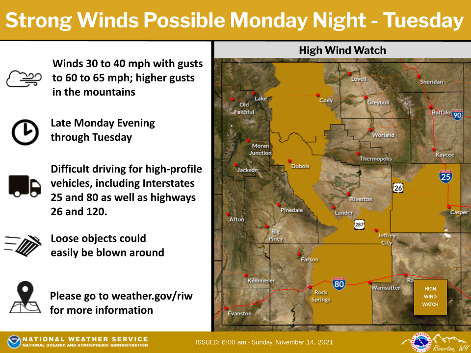
Courtesy National Weather Service, Riverton Office
A High Wind Warning – with possible winds as strong as 75 m.p.h. – is in effect in Cody, Powell, and Meeteetse until the afternoon of Tuesday, Nov. 15.
West winds of 30 to 40 m.p.h. – with gusts up to 60 m.p.h. – are possible along the Cody Foothills. Winds up to 75 m.p.h are possible in the mountains, including all of Highway 120 from Thermopolis to the Montana state line and the Chief Joseph Highway.
The High Wind Warning for Park County remains in effect from 8:00 p.m. Monday until 11:00 a.m. Tuesday.
Wind this strong comes with added risk to high-profile vehicles, like R.V.s and tractor-trailers. If they are traveling and lightweight, there’s a higher chance of vehicle blow overs.
The hurricane-force winds are literally changing the season as more wintery weather moves into Park County as the week goes on.
High clouds and mild temperatures covered Wyoming this weekend. But the N.W.S. Riverton is calling for “big changes” starting Monday night.
A timeline has been released by the N.W.S. It tentatively lays out what will be happening when and when winter comes to northwest Wyoming.
Day One: The evening/night of Sunday, Nov. 14
- Gusty west winds in excess of 45 mph are possible along the Wind Corridor from Sweetwater County through Natrona County and in the Cody Foothills through the early overnight hours.
Days Two Through Seven: Monday, Nov. 15 through Saturday, Nov. 20
- A cold front brings strong west and northwest winds to the region. As a result, light accumulating snow is likely in the mountains and for elevations over 7500 ft.
A cold front will reach northwest Wyoming sometime Tuesday night, which could cover Cody and Park County under a light blanket of snow. This mainly affects the Chief Joseph Highway, as Cody is only 5,016 feet above sea level.