Bighorn Basin Blanketed in Up to Six Inches of Snow
Written by Andrew-Rossi on February 14, 2023
The latest winter storm is dropping snow on the Bighorn Basin, but temperatures will not drop to anywhere near the extreme lows of the last storm.
The National Weather Service Office in Riverton issued a Winter Storm Warning for the entire Bighorn Basin earlier this week. The warning remains in effect for 24 hours – 5 a.m. Tuesday, Feb. 14, to 5 a.m. Wednesday, Feb. 15.
Unlike previous storms in Winter 2022-2023, this week’s storm will not be accompanied by sudden, devastating drops in temperature. The lowest temperature over the 24-hour period is 4 degrees on Tuesday night/Wednesday morning. Otherwise, temperatures across the region should stay in the high 20s to low 30s.
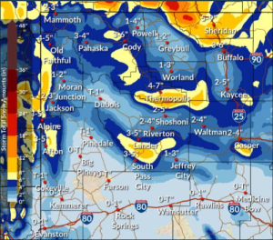
Courtesy N.W.S. Office Riverton
Anywhere from two to six inches of heavy snow is expected through the Bighorn Basin, which means roads and highways could be hazardously slick.
Total snow accumulations of three to six inches are anticipated in the Cody Foothills, North Bighorn Basin, Southwest Bighorn Basin, and Southeast Bighorn Basin. In addition, at least one to three inches is expected over the eastern portions of the basin, from Lovell to Worland.
However, the storm is also bringing strong winds – but what else is new? Bighorn Basin residents should expect “winds gusting as high as 55 mph, mainly Tuesday afternoon and evening.”
The N.W.S. Riverton Office and W.Y.D.O.T. remind drivers to plan on slippery road conditions, as areas of snow blowing could significantly reduce visibility. The hazardous conditions could impact the morning and evening commutes.