Park County Got More Snow Than Predicted – A Lot More
Written by Andrew-Rossi on February 16, 2023
Tuesday’s snow fell fast and hard, quickly surpassing the anticipated two to six inches over the 24-hour period, which should build up the region’s slightly lower-than-normal snowpack.
Before the first flakes fell on Tuesday morning, the National Weather Service Office in Riverton had already issued a Winter Storm Warning and told Bighorn Basin residents to brace for a big one. That prediction was certainly realized, but many communities found themselves more buried than they thought.
The Iowa State University Environmental Mesonet published the raw numbers of snowfall recorded by the National Weather Service in western and central Wyoming on Feb. 14.
Based on N.W.S. predictions, most of the Bighorn Basin would receive between one and four inches of snow, mainly on Tuesday. And most of the region received that amount – and quite a bit more.
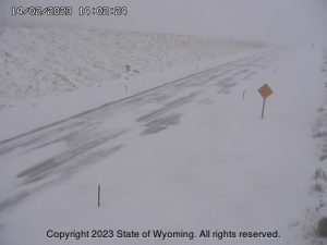
Courtesy State of Wyoming
The highest amount of snow recorded in the Bighorn Basin was a whopping 18 inches in Wapiti in that 24-hour period.
Based on N.W.S. projections, Wapiti would receive between three to six inches. This means more snow fell in Wapiti than any other location in the Bighorn Basin and the State of Wyoming during Tuesday’s storm.
Most of Cody was hit hard, too. Between six and nine inches covered Cody before the storm subsided. All of Park County was hit hard by the storm, with Meeteetse recording nearly five inches.
The following is the highest amount of snow recorded in each county in the Bighorn Basin:
Big Horn County
- 4.0 inches in Shell
Hot Springs County
- 10 inches in Thermopolis
Park County
- 18 inches in Wapiti
Washakie County
- 6.0 inches in Worland
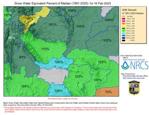
Courtesy Water Resources Data System & State Climate Office
Heavy snow is good news for northwest Wyoming’s snowpack, which has been hovering at 90-95% of median values for most of Winter 2022-2023.
While more of the state is getting thoroughly saturated, the river basins in northwest Wyoming have been wanting for snowpack. The latest report from the Water Resources Data System & State Climate Office shows the Shoshone River Basin is at only 88% of its median snowpack. The snow water equivalent was as high as 98% on Jan. 9.
Meanwhile, the Yellowstone River Basin is doing slightly better at 91% median snowpack. However, that’s a drop of 17% since mid-January.
While it’s still too early to tell, Tuesday’s snowstorm will hopefully build needed snowpack in northwest Wyoming. That growth will ensure the region doesn’t get precipitously dry in the upcoming summer, which results in struggling agriculture and a higher risk of wildfires.