New WSGS Map Improves Safety in The Ramshorn Quadrangle in Park & Fremont Counties
Written by Andrew-Rossi on June 8, 2023
A new Wyoming State Geological Survey (W.S.G.S.) map depicts the geology of one of the state’s most landslide-prone regions. It offers new insights into the recent geologic history of the area. The map focuses on the surficial geology—landforms and unconsolidated deposits at the ground surface—of the west half of The Ramshorn 30′ x 60′ quadrangle in northwest Wyoming.
“Surficial geologic mapping is fundamental to understanding what materials exist at the earth’s surface and how they’re distributed across the landscape. These data are used by land managers, local governments, and the public to make informed land-use decisions, and they have wide-ranging applications from infrastructure siting to real estate to emergency management,” says Dr. Erin Campbell, W.S.G.S. Director and Wyoming State Geologist. “This map and accompanying report align with the W.S.G.S.’s mission to characterize Wyoming’s geologic resources and hazards, and they bring the agency closer to its goal of completing 1:100,000-scale surficial geologic mapping across the entire state.”
The Ramshorn quadrangle encompasses the northwestern Wind River Range and Wind River Basin and the southern Absaroka Range. U.S. Highway 26/287 runs through the southwest corner of the map. The roadway is an important transportation corridor linking central Wyoming with Yellowstone and Grand Teton national parks and has been historically impacted by landslide activity.
The only prior landslide inventory in the area was completed over 20 years ago without field verification. As part of their mapping on the west half of The Ramshorn quadrangle, W.S.G.S. geologists updated the previous landslide inventory by interpreting 1-meter-resolution, bare-earth lidar data and select ground truthing.
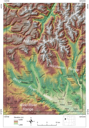
Courtesy Wyoming State Geological Survey
In addition to assessing geologic hazards within the map area, the project provides more understanding of the Pleistocene glacial systems in the Wind River and Absaroka ranges. The mapping documents the position and extent of glacial till and outwash deposits in the upper Wind River valley. It correlates them with similar deposits that have been mapped outside of the study area.
A notable finding from this work is the recognition that glacial ice from the Wind River Range and Greater Yellowstone Region likely coalesced in the southwest corner of the quadrangle during the Bull Lake glaciation—the second to last Rocky Mountain glaciation that occurred approximately 150,000 years ago. W.S.G.S. geologists documented the lithologic composition of glacial till to reconstruct glacier source areas and provide evidence for incorporating distinct rock types from the Wind River and Absaroka ranges into these deposits.
The W.S.G.S. used digital and field methods to complete the mapping. Due to the remote nature of the map area—most of the northern half is part of the Washakie and Teton wilderness areas and lacks road access—initial mapping was completed by interpreting lidar data and aerial photographs. This was followed by five weeks of field mapping in which geologists visited targeted locations of high landslide density, exposed glacial deposits, and places needing refined mapping. One week was spent mapping from a backcountry base camp along the South Fork Shoshone River, which required a 20-mile one-way horseback ride to reach.
“The remote nature of this map area was both a challenge and an opportunity,” says W.S.G.S. geologist James Mauch. “We had to lean heavily on digital methods of lidar and image interpretation to map the surficial geology of much of the northern half of the quadrangle. The inaccessibility of this area also meant that there was little previous mapping—in many places, only consisting of very coarse-scale work from the statewide map—which gave us a blank slate to make our own original interpretations. It was refreshing to map in this manner.”
The Preliminary Surficial Geologic Map of the West Half of The Ramshorn 30′ x 60′ Quadrangle, Fremont and Park Counties, Wyoming, Open File Report 2023-1 is available as a free downloadable PDF and as a hardcopy for purchase from the W.S.G.S.
A 34-page report complements the map and includes information about the quadrangle’s previous mapping efforts, geologic setting, methods used for this project, map unit descriptions, and interpretation of the area’s Quaternary geologic history.
The 1:100,000-scale geologic map was funded through the U.S. National Cooperative Geologic Mapping Program, managed by the U.S. Geological Survey.