Wyoming and Montana Wildfires Filling Skies with Smoke
Written by Andrew-Rossi on June 13, 2021
The first wildfires of 2021 are burning in northern Wyoming and southern Montana – an ominous sign for summer during an ongoing drought in northwest Wyoming.
It’s officially wildland fire season in Wyoming, and fires are already igniting throughout the Bighorn Basin. As of June 13, there are three wildfires burning in the Bighorn Basin. Each one large enough to merit an official response from firefighting teams with the Bureau of Land Management or U.S. Forest Service.
The Robinson Fire
According to InciWeb, the Robinson Fire located 20 miles south of Buffalo Wyoming. Started by lightning on Tuesday, June 8, high winds are pushing the fire further into Robinson Canyon where it is now burning through approximately 790 acres of “extremely step and rocky terrain.”
As of Sunday, June 13, the fire is 25% contained with 236 personnel on the scene. Helicopters with buckets are working as best they can, but strong winds are making it impossible for aircraft to work in the canyon.
A Rocky Mountain Area Blue Team (Type 2) is currently coordinating the firefighting efforts.
The Robertson Draw Fire
The Robertson Draw Fire is located 33 miles east of Cooke City, Montana in Custer Gallatin National Forest. Currently, there is little information available on the blaze, including its size and containment percentage.
According to the Custer Gallatin National Forest website, there is a 1.4-mile hiking and biking trail going along the Robertson Draw. The terrain is described as rocky and bumpy and closes annually from Dec. 2 to April 14.
Smoke from the Robertson Draw Fire is visible along the Beartooth Pass and as far away as Clark. A Facebook post confirms that the fire departments of Red Lodge, Belfry, and Bridger, along with the U.S. Forest Service, are currently responding to the incident.
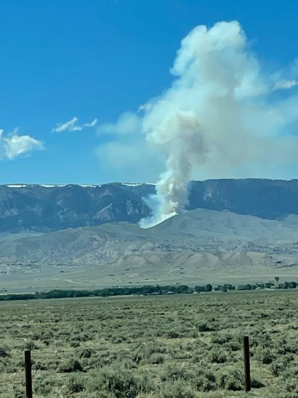
Courtesy Stefanie Bell
The Sheep Mountain Fire
Another fire has been reported on Sheep Mountain, approximately eight miles from Greybull. While the fire is currently active, no additional information is available.
While the fire is burning on B.L.M. land, it has yet to get an incident page on InciWeb. Both the Robertson Draw and Sheep Mountain Fires are currently categorized at “minimal to low risk” by the Wyoming Wildfire Map.
Wildfires are a common occurrence during a Wyoming summer, but any fire this year will burn more intensely due to drought conditions throughout the Bighorn Basin.
Governor Mark Gordon announced the launch of a new website to provide drought information to Wyoming residents.
Most of northwest Wyoming is either abnormally dry or in severe drought – including the areas where fires are burning. Earlier this year, 19 Wyoming counties were designated as Primary Natural Disaster Areas due to drought conditions.
For the most up-to-date information on wildland fires in Wyoming, visit the Wyoming Wildfire Map, presented by the True North Fire, Weather, and Avalanche Center.
For information on fires burning on N.P.S. or B.L.M. land, visit InciWeb.