Wyoming’s Snowpack Lower Than Average for December
Written by Andrew-Rossi on December 18, 2020
Many are hoping for a Wyoming White Christmas, but global weather patterns mean many will have to keep hoping.
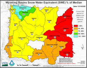
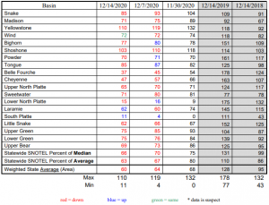
The US Department of Agriculture released their first snow report for Water Year 2021 – which encompasses the entire 2020-2021 winter season. The overall assessment of “snow water” so far is lower than historic medians across the entire state. Much lower.
Basins across the state are reporting that the current level of snow pack is low. The lowest was recorded in eastern Wyoming – the South Platte Basin at the southeast corner of the state is so “dry” it can only account for 11% of the median value for this time of year.
Northwest Wyoming is the only part of the state that’s doing better than the median. The Shoshone Basin reports 103% of its median value, and the Yellowstone Basin reported 110%.
Is this any cause of concern?
No.
Jim Fahey, a Wyoming hydrologist with the Natural Resources Conservation Service in Casper, says that global weather patterns are dictating where snow falls in Wyoming – and how covered it gets.
“Meteorologically, we are supposedly in a la Nina situation. The last two months have been a moderate to strong signal. So we’re looking to get more storms from that, especially in northern Wyoming. It does pick up some precipitation with that pattern. Central and south Wyoming notoriously stay dry with that pattern.”
La’Nina, the counterpart to the more infamous El Nino, is an ocean-atmosphere phenomenon that occurs every few years and can last for up to five months. It can lead to intense storms and droughts simultaneously, which would explain why the Yellowstone area is seeing above-average snowpack for this time of year while much of Wyoming remains dry.
While this may sound disconcerting, Fahey explains that the bulk of Wyoming’s snowfall is yet to come. It’s still too soon to say how much snow will get packed into the state.
“It’s way too early, especially for basins east of the Continental Divide. We get all our precipitation – up to 50-60% of our precipitation – from March to early June. So, it’s still way too early, and it’s still way too early for areas west of the continental divide as well,” he said.


