Wyoming Warm and Dry in December – Is There Snow Relief?
Written by Andrew-Rossi on December 15, 2021
While it’s too early to say how much moisture Wyoming will receive this winter, below-average snowpack across the state is already a worrisome sign for 2022.
November might have been enjoyably warm in Wyoming, but it’s not great news for the state. According to the National Oceanic and Atmospheric Administration, November’s average temperature was about 6 degrees Fahrenheit warmer than average.
Unseasonably warm temperatures already have a direct economic impact. For example, several Wyoming ski areas – including Sleeping Giant – are delaying their winter openings due to a lack of natural snow and the inability to make more.
What does this mean for 2022?
The Wyoming Natural Resources Conservation Service released its first Wyoming Snowpack and Snow Water Equivalent update on Tuesday, Dec. 14.
According to the report, authored by N.R.C.S. hydrologist Jim Fahey:
- Wyoming’s snowpack/S.W.E. is currently 66% of median–with a basin high of 92% (Powder) and a basin low of 7% (South Platte.) At the same time last year, the state’s snowpack was 71% of the median; and 130% of the median in 2019.
- In the next seven days, precipitation/snowfall totals will be the highest over the western mountains. Expect two to three inches of precipitation (15 to 20 inches of snowfall) at the higher elevations (above 9,000 feet) in western Wyoming Tuesday through Thursday. Lower chances for mountain snowfall across Wyoming Friday through Monday of next week.
- Minimum and maximum temperatures are expected to be near normal to slightly above normal across most of Wyoming in the next seven days.
For northwest Wyoming, there’s a stark contrast. The following images compare the snow water equivalent on the same date – Dec. 14 – in 2020 and 2021.
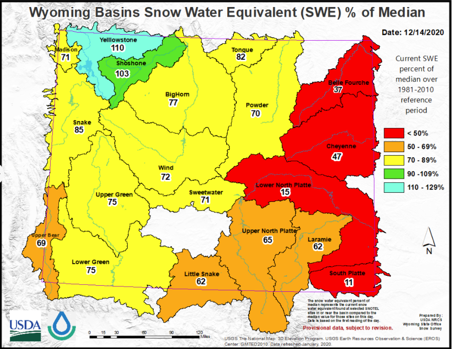
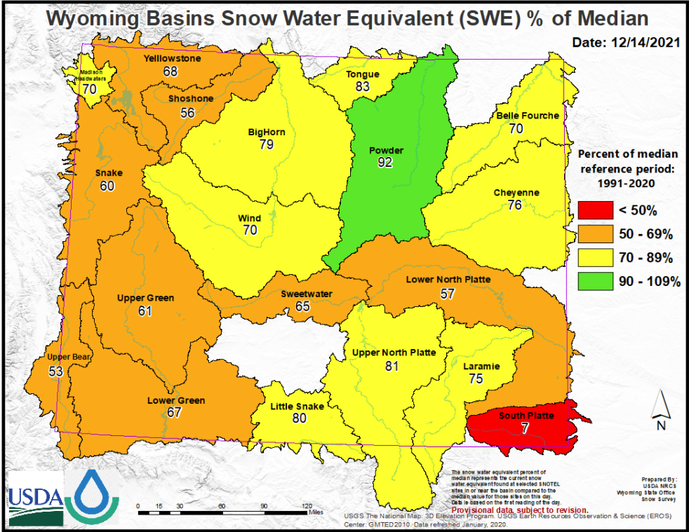
Courtesy Wyoming N.R.C.S.
For the rest of December 2021, northwest Wyoming should feel like usual – if we’re lucky.
The N.O.A.A. anticipates N.W. Wyoming will experience normal or near-normal temperatures from now until Dec. 24. That means there’s a good chance of snowfall at the higher elevations, which is good news for the region’s winter recreation industries.
Meanwhile, the rest of Wyoming is expected to be warmer than average during the same period – 30-50% warmer. If such patterns persist, it doesn’t bode well for the upcoming winter, next spring, or a potentially even more treacherous summer fire season.
Furthermore, the Western Hemisphere is still amid La’Nina – an ocean-atmosphere phenomenon that occurs every few years and can last for up to five months. It can simultaneously lead to intense storms and droughts.
La’Nina brought above-average snowpack to Cody and Yellowstone National Park in December 2020. But that surplus didn’t flow into spring, with reservoirs throughout the Bighorn Basin below their average capacity by June.
Historically, La’Nina tends to favor northern Wyoming, bringing lots of rain and moisture. But this doesn’t bode well for southern Wyoming, which will continue to be drier than average – and the region is already in the midst of a drought.
One other factor to consider is that it’s still too early to say what kind of winter Wyoming will experience despite the lack of snow so far.
“It’s way too early, especially for basins east of the Continental Divide,” says Fahey. “We get all our precipitation – up to 50-60% of our precipitation – from March to early June. So, it’s still way too early, and it’s still way too early for areas west of the continental divide as well.”
This week’s weather might cover northwest Wyoming with snow. However, temperatures will rise up to the 40s by the weekend, which could melt anything that sticks to the ground.

Continue reading